The Blanchard and Langdon map, published in 1756, is one of the earliest depictions of the New Hampshire colonial towns stretching from New York to the Atlantic Ocean. The crop at the bottom of the page highlights the Connecticut River Valley.
What can you say about the Native American presence by looking at this map?
What parts of the region have been surveyed?
Where are the forts?
Where have towns been established?
Where are the roads?
How might the map entice settlers to travel up the Connecticut River to settle?
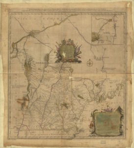
Clicking on the map will take you to the Library of Congress where you can download a high-res version. Below is a crop of the map.
